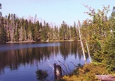
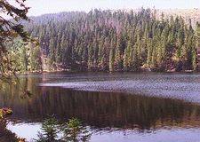
Prášilské Jezero (Prášily Lake) lies on the slope of Poledník mountain ("Noon Mount" - 1,315 m), 1,080 m a.s.l., about 5 kilometres south-east of the small village Prášily and about 10 km south-west of the village Srní.
It is one of five morainic lakes in the Czech part of the Šumava mountains (Bohemian Forest). It is about 280 m long and 180 m wide lake with girth 730 m. The lake is 3.91 ha large and the deepest point is at 15 m. The moraine, which holds 275,000 cubic metres of water, is 9 m high. The rock face towers above the water level to the height 150 m.
|
|
|
This area along the border was forbidden for the public in the second half of the 20th century, during the communist era. Now it is protected in a nature reserve (about 158 ha large) together with Poledník mountain.
The red marked path from Prášily (4.5 km) leads to the lake. The access is also possible from the parking-lot which lies about 2 km east of Prášily (in the direction of the village Srní) along the yellow sign continuing along the green one and then the red one (about 4 km).